 Dursun Yıldız, April 1 2026
The Litani River, located entirely within Lebanon, extends approximately 170 kilometres, making it one of the country’s longest rivers. It originates in the Bekaa Valley and flows south and west before discharging into the Mediterranean Sea near Tyre. The river basin spans roughly 2,175 square kilometres and is essential for agriculture, domestic water supply, and hydroelectric power generation. The Litani River Authority, established in 1954, manages these resources and oversees the Qaraoun Dam, which stores 220 million cubic meters of water and produces approximately 775 GWh of electricity annually. The river supports the irrigation of crops such as wheat, potatoes, and citrus, accounting for about 35% of Lebanon’s agricultural output. Nevertheless, significant pollution from untreated industrial waste, agricultural runoff, and sewage poses ongoing threats to downstream water quality and public health.
The Litani River Basin is undergoing a rapid transformation from a development-oriented water system to a militarized hydropolitical frontier. Since 2023, Israeli military operations in southern Lebanon have not directly targeted water resources; however, they have indirectly impacted water governance, infrastructure, and basin stability. Although water is not the principal cause of the conflict, ongoing hostilities are significantly altering the region’s water system.
Strategic Importance of the Litani River Basin
Following the escalation after the Israel–Hamas War, the Lebanon–Israel border, especially the area south of the Litani, has become an active low-intensity conflict zone. Israeli airstrikes and artillery have targeted southern Lebanon, primarily south of the Litani line, with a focus on Hezbollah infrastructure, villages, transport routes, and bridges. As of late March 2026, there has been no full-scale ground invasion extending to the Litani River as a permanent occupation line.
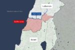
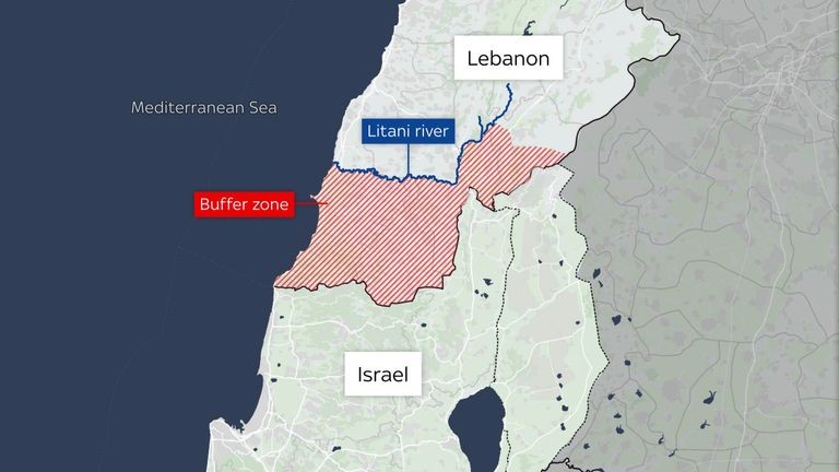
The Litani River as a Boundary in Conflict Geography and Hydropolitical Risks
The Litani functions as both a river and a geopolitical boundary. Following the 2006 war, the United Nations Interim Force in Lebanon (UNIFIL) was deployed south of the Litani to serve as a buffer zone, officially restricting Hezbollah’s presence. At various times, Israel’s security doctrine has sought to “Push hostile forces north of Litani,” thereby establishing a de facto security belt. The river thus serves as both a natural and political threshold.
Irrigation canals, pumping stations, and the Qaraoun Reservoir are vulnerable to airstrikes, which may disrupt power supply and threaten food security in southern Lebanon. The ongoing conflict exacerbates existing pollution, as fuel leaks and debris further contaminate the river. Disrupted wastewater systems also contribute to soil and water pollution. Limited state capacity in conflict zones often results in inadequate monitoring and basin management, leading to uncontrolled withdrawals and illegal abstraction.
Impact of Israel’s Invasion on Litani Hydropolitics
There is no confirmed systematic targeting of the river as a water resource; however, indirect impacts are substantial. Military operations near the basin result in collateral hydrological damage. The situation does not constitute a “water war,” but rather a “water system under conflict stress.”
If Israel establishes a buffer zone extending to the Litani, this action could trigger large-scale displacement northward, disrupt irrigation systems, and fragment basin management. These developments would constitute a significant shift in regional hydropolitics. In the event of a full regional war, basin infrastructure could collapse, resulting in long-term contamination and loss of institutional control, as observed in the degradation of water systems in Iraq and Syria following conflict.
The Litani has transitioned from a river basin governance issue to a security line. During the current conflict, Israeli officials and military actions have designated the area south of the Litani as a key military zone. Reuters reported evacuation orders for residents south of the river, bridge strikes, and a statement by Finance Minister Smotrich asserting that “the new Israeli border must be the Litani,” although this does not reflect official state policy.
The Litani case demonstrates a shift from integrated water resources management to conflict-driven, fragmented governance. Although water is not the primary source of conflict, the situation is restructuring water systems. The Litani Basin is destabilized both hydrologically and institutionally, even though it has not been directly weaponized. Previously, hydropolitics focused on water use, irrigation, power generation, pollution, and governance. The current emphasis has shifted to territorial control, buffer-zone strategies, infrastructure denial, civilian displacement, and emergency water access. While the invasion has not resulted in a traditional water war, it has transformed the river basin into a militarized hydropolitical frontier.
Proximity to the Litani River
As of late March 2026, there has been no full Israeli invasion reaching the Litani River, although the situation remains fluid. Israel’s military posture in southern Lebanon appears to have shifted from limited cross-border strikes to a full-scale ground operation with territorial control objectives. Reports indicate that Israel is establishing a security or buffer zone extending to the Litani River, covering an area approximately 20 to 30 kilometres deep. This would provide military control and proximity to the river, with the operation prioritizing security and territorial depth rather than direct control of the Litani. Nevertheless, proximity to the river may offer strategic advantages. Israel’s long-term objectives in southern Lebanon may differ from previous operations and could include shifting the burden of the Palestinian population in Gaza and the West Bank to neighboring countries or taking steps toward this outcome. Previous plans for the region’s water needs may also be reconsidered. Consequently, Israel’s actions in southern Lebanon may be part of broader medium- and long-term regional strategies, including water management.
Author
Dursun Yıldız (MSc.) is a hydropolitics specialist and serves as Director of the Hydropolitics Association in Ankara, Türkiye. He is a civil engineer and previously served as Deputy Director at the State Hydraulic Works in Türkiye. His academic background includes a postgraduate course in hydroinformatics at IHE Delft, technical training at the United States Bureau of Reclamation, and a master’s degree in Hydropolitics from Hacettepe University, Türkiye.